Truro and Kenwyn contain considerable areas of biodiversity and locally significant landscapes. The Fal and Helford Special Area of Conservation extends into the Plan area and the Carine Common SAC is located close to the Gloweth area. Green fingers extend down through valleys almost into the centre of Truro at the Coosebean and Allen Valleys. The rivers Kenwyn and Allen flow through the centre of Truro and the River Tinney runs through the valleys to the south of the Plan area.
- The area in and around Truro and Kenwyn has a high quality built and natural environment with a variety of landscapes.
- The agricultural sector accounts for a large amount of environmental land use and working with these landowners is key for effective implementation of conservation plans and policies.
- The Truro and Kenwyn area is a landscape dominated with sloping hills and river valleys, with various rivers flowing through the City and a city centre vulnerable to flooding from rivers and the sea. Planning for a sustainable and vibrant future will have to pay close attention to this as flood risk changes with climate change and sea level rise.
- Environmental risks must be factored in to any developments with reduction of these essential for sustainability of projects and where damage is unavoidable: habitat creation can serve as the tool to maintain local biodiversity and the ecosystem services that provides.
- There are many links to green infrastructure and this will be pivotal in reducing the need to use cars, increasing journeys by foot and cycle and, subsequently, reducing local congestion and unnecessary carbon emissions as a result.
- Good quality local amenities will be important for the quality of life afforded by the community. Recreation areas, allotments and multi-functional facilities should be prioritised within the Plan area.
A Green Infrastructure Plan has been developed alongside this Plan and helps to set out our approach to the environment and to assist the delivery of projects that help to meet the environmental aims of this Plan

What does the plan propose for the Environment?
- Sustainability: To make new development as sustainable as it can be. Development should have the minimum possible effect on the environment and the effects of climate change should be taken into account in planning new development This means increasing density of development where appropriate and making sure that new buildings consume less resources when they are built and into the future through greater energy efficiency and reducing the need to travel.
- Biodiversity: To protect and enhance biodiversity in the Plan area, whilst identifying opportunities to create linked woodland and green corridors. This aims for a net increase of biodiversity over the Plan period and promote ecosystem services in the area.
- Food production: Both of the Parishes’ strong links with agriculture need to be sustained. The Plan seeks to avoid the loss of agricultural land.
- Mitigation: New developments should not cause an environmental risk to either the current or new community through flooding or sewage flooding. The creation of boundaries between the environment and these developments also needs to be ensured.
- Green infrastructure guidance: Green infrastructure is a vital part of life in our area. Further guidance has been developed to identify opportunities to plan for new open spaces, links between natural and built environment, increase biodiversity and protect the environment.
Sustainable Development in Truro and Kenwyn
In drawing up the Neighbourhood Plan we have produced a definition of sustainable development for our area. In terms of setting a standard for new development we have defined what we mean by sustainable development:
Sustainable development:
Sustainable, appropriate development is development that meets current human need without compromising natural capital. It takes account of the needs of future generations, other species, and the carrying capacity of the planet. It recognises the intrinsic value of nature and the protection of the environment.
We want our community to be resilient enough to withstand future shocks, notably climate change and resource depletion, for example by enhancing food and energy production. We want Truro and Kenwyn to thrive under a new era of community cohesion and localism.

E2. Sewage, sustainable urban drainage and water reuse
Flooding is an issue of growing importance in the Plan area; there is existing flood risk from rivers, sewage and the sea and this risk is increasing as the climate changes. It is important that new development does not reduce the ability of the landscape to accommodate heavy rainfall without flooding. Sustainable Urban Drainage (SUDs) is integral to this policy and ensures that development incorporates mechanisms to replicate the rate at which water flows off the landscape on which it has been built.
 It is also vital that adequate sewerage and treatment facilities are made available to serve a development to ensure that sewage flooding and the risk of potential harm to the sensitive waters of the Truro River and Fal and Helford Special Area of Conservation does not increase as a result of the proposed growth during the Plan period.

E3. Sewage facilities
Development proposals will be permitted where adequate sewage treatment facilities are available or where suitable arrangements are made for their provision.
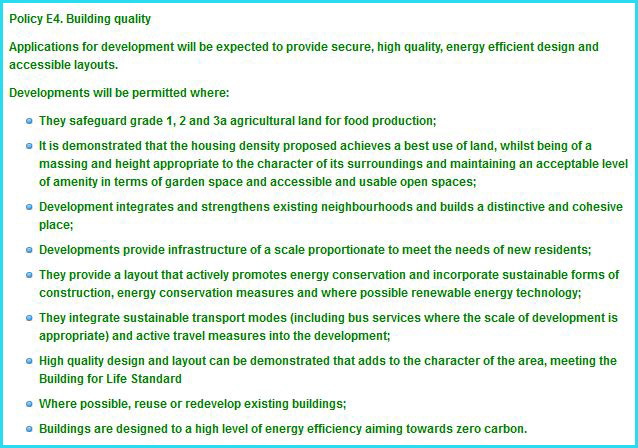
E4. Building quality
This Plan intends to create a legacy of better living standards for the community and the people of different ages, incomes and interests in the area. This means good quality housing that is suited to the needs of the community and built with sustainable construction practices that are efficient to run.
Achieving an appropriate housing density is a key consideration in this policy, with each property requiring access to a minimum amount of green open space. However, as we approach the more densely populated areas (such as the city centre) less space is physically available. This has to be reflected in the amount of space made available per property, but will also be partially offset by strong transport links to open and green spaces within and surrounding the Plan area.
There is a growing interest in sustainability within the community regarding energy efficiency and energy production. This is reflected in this policy regarding the standards to which developments are to be constructed.
Connecting all parts of the community to the best amenities that Truro and Kenwyn, and the surrounding area have to offer can create a more desirable and productive community into the future. Whilst there are a number of social facilities across the city, some are less well served than others, for example community meeting space in the city centre is limited. Where this is the case, new development should make contributions to the provision of new social infrastructure.
The reuse and adaptation of existing buildings can help to reduce carbon emissions and help to create interesting developments.
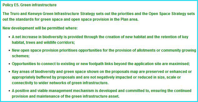
E5. Green Infrastructure, local food production and access to the countryside
Communities are reliant on the natural environment they are located in for much of their resources and amenities. Having a healthy natural environment is an essential insurance policy against the challenges of a changing climate. An environment with a greater number of species thriving within it, will effectively have more species options to fit the climatic conditions in the area under future climate change. We cannot entirely know what the environment will be like in future so we need to provide habitat and biodiversity corridors that ensure species can continue to adapt and thrive.
The Truro and Kenwyn area is fortunate enough to have a superb environment, with two European designated areas at Carrine Common and the Fal and Helford River complex. To prevent recreational pressure on Carrine Common from growth in the Plan period we have identified a strategic open space at Coosebean, which the Green Infrastructure Strategy seeks to enhance to provide a place to walk, cycle and explore. We have allocated this area under policy LC2 of this Plan.
A Green Infrastructure Strategy1 has been created alongside this Plan to ensure that new green spaces can be created and existing spaces and linkages between them can be improved for the future. The strategy is an important balance to new development in the area and contains a number of projects that will improve access to green spaces. We will champion the strategy and ensure that new developments and community action help to deliver the projects in the strategy. This policy links to policies LC1 and LC2 that seek to provide new green spaces and protect important green spaces that contribute to the character and appearance of our area.
E6. Character and setting of settlements:
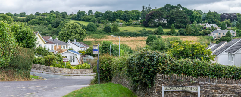
The quality of the environment around our settlements of Truro, Threemilestone and Shortlanesend is valued by the community. This comprises both the landscape setting of the settlements and also the spaces around and setting of buildings. Both Truro and Shortlanesend have definite urban/rural boundaries and this character is important to the setting of those places. In both the settlements and the surrounding area character is influenced by the quality of the spaces and structures that form the roads and byways of our area.
A number of landscape studies and strategies have identified important landscapes and green gaps in and around Truro and Threemilestone. The Truro and Threemilestone Landscape Strategy (2008) demonstrates the importance of the undeveloped ridge tops to the setting of Truro and the lower valley slopes to the setting of Threemilestone and Highertown. Additional work will be carried out to understand the setting of Shortlanesend. Other important green areas have been shown on the proposals map for this Plan to support Policy LC2 (Locally protected green spaces), although it must be noted that this cannot ever represent a list of all important green areas in Truro and Kenwyn.
Sustainability
These policies aim to contribute to sustainable development by:
- Providing a local interpretation of sustainable development
- Setting standards for build quality, energy efficiency and accessibility;
- Encouraging sustainable transport modes;
- Promoting environmental sustainability;
- Helping to deliver Green Infrastructure potential
National Planning Policy Framework (NPPF):
NPPF4: Promoting sustainable transport
NPPF7: Requiring good design
NPPF8: Promoting healthy communities
NPPF10: Meeting the challenge of climate change, flooding and coastal change
NPPF11: Conserving and enhancing the natural environment
Cornwall Local Plan:
1: Sustainable development
12: Design
13: Development standards
16: Health and well being
22: Best use of land and existing buildings
23: Natural environment
22: European Protected sites
25: Green infrastructure
26: Flood risk and coastal change
27: Transport and accessibility
Who will assist with delivering the aims of environmental policy?
- Local Nature Partnership;
- Cornwall Council;
- Private Sector providers/businesses;
- Renewable providers;
- Land owners and developers.
- Voluntary and charitable organisations
Historic environment in Truro and Kenwyn:
Truro and Kenwyn are both historic places with ancient roots; Bronze Age settlements have been discovered in both the east of the city and in the Threemilestone area. The core of Truro is Georgian, but much of the older part of the city is Victorian, with a compact, terraced form. The Highertown area expanded rapidly from the 1930’s onwards, creating a new area of the city along the Highertown ridge and departing from previous development that had remained in the landscape ‘bowl’. Threemilestone and Shortlanesend expanded considerably in the 1970’s.
The history and wealth of Truro has resulted in a rich heritage of buildings and spaces that are much appreciated by residents and visitors
What does the plan propose for historic environment?
-
Adopting the principles of the Conservation Area Masterplan:
The Truro Conservation Area Masterplan has provided a snap shot of the quality of the Conservation Area and some of the issues that need to be resolved as well as the areas that need to be celebrated. This is reflected in the policies that seem to retain the essential character of Truro in development proposals.
-
Celebrating the history of the area:
The history of the area goes beyond the heart of the conservation area. Our policies seek to ensure that historic assets are respected wherever they are in the plan area, recognising the wealth of architectural and archaeological features across Truro and Kenwyn.
-
Improving the quality of development:
The policies of this Plan seek to achieve the very best of development for Truro and Kenwyn and historic environment policies should always be read in conjunction with our other development standards polices. Development should always add to the quality and interest of the historic environment.
Historic environment policies
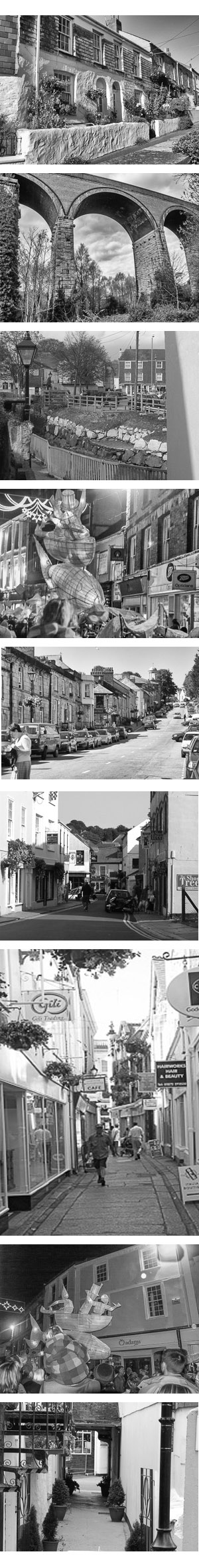
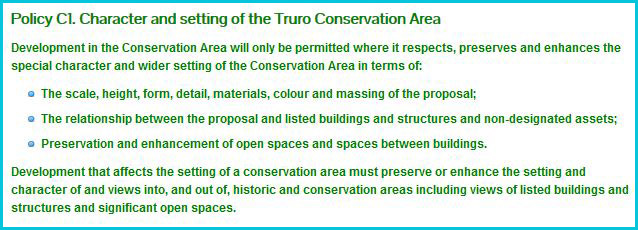
C1. Character and setting of the Truro Conservation Area
The entire Truro city centre and much of the surrounding area is designated as a Conservation Area. This was reappraised and extended in the Truro Conservation Character Area Assessment and endorsed by Cornwall Council in April 2010. It is particularly important that the character of the Conservation Area, made up of a combination of buildings (including listed, unlisted and non-designated assets), streets and spaces is protected and enhanced. A Conservation Area Management Plan was created in 2008 and has been endorsed by the City Council and Cornwall Council in April 2010. This helps to describe the character of the Conservation Area and its special spaces and materials. development standards polices. Development should always add to the quality and interest of the historic environment.
The City Council will seek to update this strategy as required within the Plan period, including the creation of a ‘local list’ of important buildings that are not statutorily listed. This will comprise of a list of undesignated heritage assets both inside and outside of the Conservation Area, endorsed by Cornwall Council for use in decision making in line with advice contained in the NPPF.
Proposals in the Conservation Area will need to take particular care to respect the features, scale, massing and materials that make up the character and appearance of the area as well as the impact on non-designated assets. Proposals outside of the area that still affect the setting of the Conservation Area must also apply care.
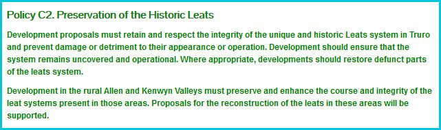
C2. Preservation of the Historic Leats
The leats are a system of open watercourses that run through many of the main streets of Truro. They form an important part of the character of the city and should be retained, enhanced and restored where appropriate.
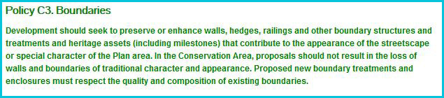
C3. Boundaries
Boundaries, consisting of walls, railings and fences add greatly to the character of the Plan area, adding containment and demarcating space. Within the Conservation Area demolition of boundaries of 1 metre or over requires planning permission, but not outside of this area. However the council wishes to ensure that all proposals (whether permitted development or not) take account of the desirability of retaining boundary treatments to protect the character and appearance of the area.
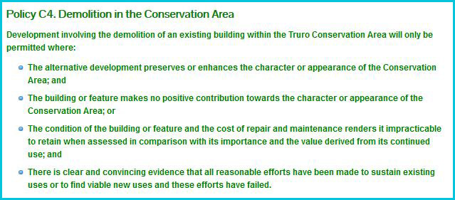
C4. Demolition in the Conservation Area
Conservation Areas are made up of a series of buildings and spaces and piecemeal erosion of the area through small scale demolitions and the loss of individual buildings can all add up to a significant impact on the character and appearance of the area. Where it is necessary or desirable to demolish a building it is important to ensure that the replacement development happens quickly to prevent detriment to the area and Cornwall Council will prefer a timetable for redevelopment is put in place to achieve this.
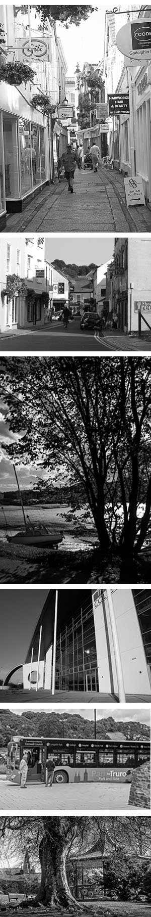
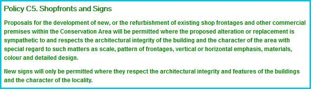
C5. Shopfronts and Signs
With so much of the city centre consisting of listed buildings and smaller scale traditional buildings it is important that the scale and materials of signage is appropriate to not only the character of the conservation area, but also to the host building. Guidance on shopfront and signage design is available from Cornwall Council to help guide applications.
Sustainability
These policies aim to contribute to sustainable development by:
- Conserving historic structures and materials
- Reusing historic buildings
- Celebrating the history and culture of the area
National Planning Policy Framework (NPPF):
NPPF7: Requiring good design;
NPPF12: Conserving and enhancing the historic environment
Cornwall Local Plan:
1: Sustainable development
12: Design
21: Best use of land and existing buildings
24: Historic Environment
Who will assist with delivering the aims of historic environment policy?
- Cornwall Council;
- English Heritage
- Private Sector providers/businesses;
- Civic Society;
- Land owners and developers.